Update: After this blog post was published, a further exchange of emails between myself and county planner Steve Kirk took place. The upshot was some clarification of areas of concern. This exchange along with two recommendations for considerataion by the Planning Commission were then sent to the public record files as testimony to be included in the May 6 hearing on the Quads Parcels CAP:
The Sarasota County Planning Commission is set to consider the county's proposed Critical Area Plan (CAP) for the area that includes the Quad Parcels and Celery Fields at a May 6, 2021 hearing.
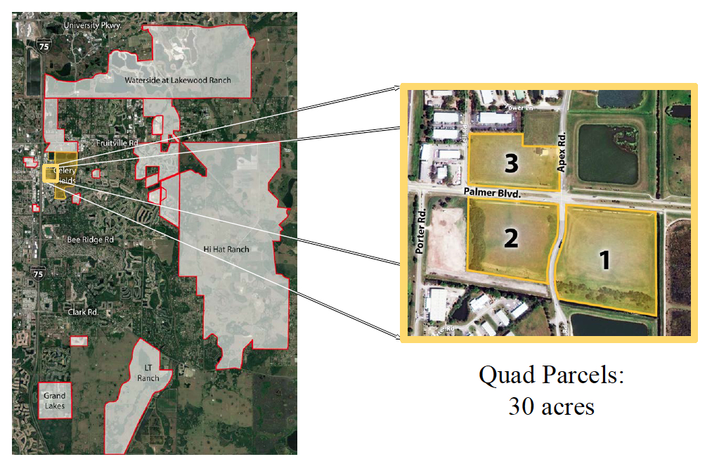
The plan proposes rezoning the Quads to Government Use (GU) and delineates constraints and recommendations to preserve and protect bird habitat and create a open vista -- a green gateway to East County.
County Planner Steve Kirk put a lot of thought into this presentation, which seeks to honor the intent behind the county's grant of a permanent easement over three of the four parcels (outlined above) to the Conservation Foundation of the Gulf Coast and to Sarasota Audubon, which has had s strong commitment to the Celery Fields, and which will manage the future redevelopment of these parcels.
Here's my email to the Planning Commission:
As one of the founding members of the Fresh Start Initiative, a community group that spent 10 months gathering community input and recommendations for the Quads parcels, I invite the Planning Commission to weigh in on the CAP as it now stands.
1. The Critical Area Plan seeks to realize the vision of a Gateway to East County, with an open viewshed, and new, Audubon-guided bird habitat. It stresses a unifying compatibility of architectural styles, setbacks, building height and more. However, while these constraints will certainly enhance the three parcels under easement, the Northwest Parcel has 4+ acres of developable land that will simply be rezoned GU. This acreage could be developed by the County or sold to a developer, with options for light industry, commercial, or residential uses.
Wide range of options for the NW Parcel
It would make perfect sense for the Planning Commission to strongly recommend that the NW parcel's 4+ developable acres have binding language stating that any proposed use must be found compatible with the larger vision for the Quads and Celery Fields Area.
A four-acre warehouse serviced by giant 18-wheelers on the Northwest parcel would hardly be consistent with the purpose of the perpetual easement, or for that matter with the roads and residential neighborhoods on and near Palmer Blvd.
The Fresh Start group did present a few community suggestions for the Northwest parcel. One that would both be consistent with the easement vision and offer practical help to motorists would be a bus loop enabling schoolchildren to get on and off buses without stopping traffic both ways on Palmer.
The loop could have a pavilion with tables where children could sit out of the rain or strong sun, and perhaps eat a snack. Snacks could be provided by a rotating series of food trucks on an area set aside for this purpose.
Not only would this use be an asset for our children and help the flow of traffic, but it would also fit with the fact that, as public land, the Northwest parcel already holds a brand new fire station in suitable Old Florida style.
2. Another noteworthy element of the permanent easement reserves the County's right to construct a building on six acres of the Southwest parcel. While the Board has spoken of using the land for a history museum, nothing in the CAP specifies this use, leaving open the possibility of some other Government Use on this parcel.
GU, however, allows a great many things -- firing ranges, bus terminals and asphalt manufacturing among them. It would be a valuable enhancement to the Planning Commission review to recommend binding the use of the Southwest parcel to consistency and compatibility with the "Prime Directive" of the permanent easement: protection of bird habitat in the Celery Fields.
Mr. Steve Kirk
Sarasota County
Planning and Development Services
1660 Ringling Blvd.
Sarasota, FL
Re: Critical Area Plan for the Palmer Blvd./Quads Area
Dear Mr. Kirk,
I appreciate your compiling the diverse attributes of my neighborhood and laying out some interpretations in the Critical Area Plan draft. This is indeed a grand undertaking, and I’m sure you’ve put in many hours!
I see: Adopted in 1985, the CAP was privately initiated and required to meet the provisions of the Comprehensive Plan to map the designated industrial area.
Click to enlarge
I would be curious to know who initiated this CAP, and if these “players” are still around today. Even back then, you would think any plan would be publicly initiated.
The draft outlines the zoning districts listed below. I believe Figure 5 should have widened the territory to include a much larger view, and the acreages should be given for residential in the wider area.
The following zoning districts (Figure 5) and acreages exist within the CAP:
PID (Planned Industrial Development) - 167.4
ILW (Industrial, Light Manufacturing and Warehousing) - 75
OUR (Open Use Rural) (Quad’s parcels) - 55.2
PED (Planned Economic Development) (SPA 3) - 29
GU (Government Use) (Ackerman Park, fire station) - 30.2
OUE-1 (Open Use Estate) (stormwater pond) - 15.7
PCD (Planned Commerce Development) - 12.3
Some of the recommended permitted uses should be prohibited, such as the following:
Light Industrial (there is enough current capacity in the industrial parks)
Office
Research laboratory
Warehouse and freight movement
Wholesale trade
Vocational, trade or business school
College or university
Vehicle service
Sale of vehicle parts and accessories
Sale of lumber and building supplies
Implementing Zoning Districts
The Comprehensive Plan identifies the implementing zoning districts for each future land use designation. The following are the implementing zoning districts identified for the MEC designation:
N.W. and S.W. Quads Industrial / Office - Suitable
Consistent with Comprehensive Plan and surrounding uses.
Low traffic generator
Retains MEC land in employment use.
An additional zoning district should be added to the UDC: Parks and Recreation. I think that this should be recommended rather than the blanket MEC. Just as the City of Sarasota is looking at amending zoning to create this set-apart district, Sarasota County should have such a zoning district.
TRAFFIC AND TRANSPORTATION
I do not see any solicitation of opinions from public/private/charter schools regarding student transportation needs. Would you please reach out to some entities for input?
Center Road and Lorraine Road The completion of the gap in Center Road between Fruitville Road and Palmer Boulevard should be considered to generally improve connectivity in the area of the CAP and complete a mobility loop through the CAP and around the Celery Fields. Alternatively, the construction of a pedestrian/bike path in the area of this gap could be considered.
The Critical Area Plan for this area necessarily involves a discussion of the
extension of Lorraine Road from Palmer Boulevard to Fruitville. Also, traffic on Palmer from Lorraine to Debrecen will soon be “F” LOS, from Debrecen to Fruitville “F”, and from Debrecen to Lorraine on Fruitville “F” (per traffic engineer Kwamena Sankah). Why does this matter? Because traffic that can’t get to Fruitville will even more clog the Apex area.
Traffic studies – current and anticipatory – are notoriously flawed. It’s impossible to believe studies will approach reality. They haven’t in the past, and that will be the future story.
Mitigating Improvements Section 3, Mobility, of this study indicated that the improvements associated with the Cattlemen Road Construction Phase II project and the construction of a roundabout or signalization of the Apex Road and Palmer Boulevard intersection will improve the roadway level of service (LOS) in the area. However, the LOS for that section of Palmer Boulevard west of Apex Road will likely continue to be below the adopted LOS. Also, identified as a mitigating improvement is the expansion to 4 lanes of Palmer Boulevard from Porter Road to Apex Road. However, that expansion would conflict with the objective of preserving the existing character of Palmer Boulevard with its open corridor and roadway section also identified in this study. With the development of any of the Quads parcels, Transportation Planning will identify certain improvements such as turn lanes that will be required to accommodate the traffic generated by a proposed use.
There really is no use that won’t increase traffic and ruin the larger neighborhood character. Keep in mind that identified capital project needs require funding of $1.2 billion. Where will money come from for creative roadway improvements that will serve the community in a respectful way?
Public/Civic – Suitable - Agree – but what?
Allowed as part of mixed use in PCD and PED. Limited to 50% of PCD. Traditional town center design requirements must be met in PED. N.W. Quad may be too small for PED design requirements
No limitations in GU district.
The public has clearly spoken about public uses, so there is no lack of input there. Any use should be put to the public test, with open communication. Any government uses (Natural History Museum?) should be also put to the public test.
Comment #1 on the Critical Area Plan for the Quads at the Celery Fields
To: Steve Kirk (skirk@scgov.net), Matt Osterhoudt (mosterho@scgov.net) Jane Grogg (jgrogg@scgov.net)
October 4, 2019
Having had the opportunity to review a draft of the Planning Department's Critical Area Plan (CAP) that concerns our public lands at the Celery Fields, we wish to offer some comments in hopes of clarifying community concerns.
Before going into detail, we wish to affirm that public lands in Sarasota County should only be considered according to community-oriented principles. A plan for public lands should:
Put people first.
Advance Sarasota’s long-held values of good stewardship and intelligent planning.
Situate the specific discussion within the larger context of changes and area trends.
Respect Sarasota’s distinguished tradition of protecting and preserving public lands.
The Draft CAP offers a detailed, balanced look into the area the Board tasked you to study. An example comes on page 15 (of draft received on Aug. 28th). The Level of Service (LOS) on Palmer Blvd. between Porter and Apex is found to be unacceptable, and the possibility of widening Palmer Blvd. from Porter to Apex to four lanes is considered. The report goes on:
“the negative impact on the character of the Palmer Boulevard corridor from such a change must be considered.”
This observation is highly significant; it’s a sign of the report's judicious approach to the task it was given. But -- and this is the crux of the matter -- the larger reality of that acknowledged "negative impact" is never fully given its due.
The ultimate welfare and fate of a substantial evolving area of beauty, recreation, community health and economic opportunity should be the primary and central concern of this plan, and so far, this most certainly is not the case.
Inadequate Scoping
In great measure this has to do with the design of the task, rather than with its execution. While the report seems to fulfill its objective, the design of that objective - its scoping - ignores all the most important issues that relate to the future of the Celery Fields area. At one time, the community had a hand in shaping the actual scope of a CAP - as with the Fruitville Initiative. Why not here?
What’s missing is an in-depth inquiry into the large meaningful trends transforming the entire surrounding area. In recent years, the Board has approved thousands of residences within walking distance. Children live and go to schools on buses that come along Palmer. The Celery Fields itself has become a valued amenity for residents and many visitors. The industrial park, on the other hand, often shows many vacancy signs.
Without taking into account the predominant features of the area as a whole, this plan misses what really matters: the public good. Imagine for a moment that someone applied to the Federal Government to frack a plot of land, and simply says, "this land is not close to any homes, let us frack." Now suppose the land sits atop Lincoln’s head on Mt. Rushmore -- should that fact be ignored?
What you were tasked to do is not ask, for example, how people living within walking distance of the Celery Fields will be affected by bringing industrial development forward to Palmer Blvd.
Compare the existing configuration with what is proposed: Ackerman Park serves to screen the industrial areas to its west from drivers on Apex Road. Putting industry on the Quads does precisely the opposite: It takes away the buffer (our public lands) and replaces them with construction on Palmer Boulevard. The result will be a continuous built barrier between the Celery Fields and the residential and commercial areas accessible via the Palmer Underpass. Industry would add more large truck traffic to Palmer, Porter, and Apex, which are now about to be impacted by trucks from James Gabbert’s Waste Transfer Facility.
Survey the entire community
There’s a great deal of knowledge about the area that this CAP should see as its duty to address -- real-life factors for thousands of people who now live there:
What do actual trends in the industrial park show in terms of vacancies, land prices, rental prices?
Why is no one seeking to purchase the MEC parcels in the 240 acres of the Fruitville Initiative for industry?
Where are the vectors that would demonstrate the obvious fact that Board actions have changed the area in an overwhelming way to residential and recreational?
Traffic analysis should include the peak times, patterns and needs of the immediate community.
How many school children ride how many buses to school that stop on Palmer Blvd.? Why do they stop right in front of the Celery Fields Parking Lot and block all traffic in both directions? How can this be improved?
How many people use the Celery Fields, at what times of day, what days of the week, for what purposes?
How many groups use the Celery Fields for sports training, environmental studies, teaching, birdwatching, picnicking, stargazing, photography, dogwalking, kayaking, exercise, wedding photos and so many more purposes?
With evermore recreational users and visitors - human and avian - from elsewhere, what plans are underway to to meet anticipated needs for parking and complementary activities such as a place to sit and enjoy a meal?
Without fully studying the area, how can you possibly plan in a way that offers reliable estimates of probable impacts?
What is clear is that the Planning Dept. was asked to look at implementing the 1975 land use designation for the Quads. Which means the task and scoping of this 2019 Critical Area Plan directs you to look away from, rather than inquire into, the greater and more fundamental questions of communal good in this changing landscape. Your findings flow ineluctably from the design of your task.
Policy and stewardship
In addition to the compromised frame, there is need for serious consideration of basic matters of stewardship, tradition, and policy. Ask anyone who has lived in Sarasota for a long time: it is not a “given” that public lands should be sold. In fact, it’s been a long-held principle in this county that public lands are public forever -- not to be sold for private development, except in rare explicable circumstances.
Our communities have shared our hopes and vision for this area with you over several years. We reiterate our expectation that you adopt community-based principles:
Put people first.
Advance Sarasota’s long-held values of good stewardship and intelligent planning.
Situate the specific discussion within the larger context of changes and area trends.
Respect Sarasota’s distinguished tradition of protecting and preserving public lands.
In addition, include in your plan strong provisions in the event the Board votes to sell or develop:
Detail specific constraints with regard to footprint, traffic, noise, architecture, lighting, noise, landscaping, business model, compatibility for any rezoning, special exception, etc.
Require a rigorous examination of any applicant’s business practice. Restaurant Depot Tampa location is served by huge trucks, and attracts a large public trade in cheap alcohol and food -- which escaped notice when the firm applied to build on parcel #3.
Restaurant Depot sought to build a warehouse on parcel #3
This is its Tampa site
Opportunity lost
Finally, why do this at all? No applicant has asked for this. The first thing this plan should state is the Board’s explanation as to why it prefers private profiteering to the public good.
Forward-looking planning for recreation and habitat preservation will not only serve the ever-expanding population of Sarasota County; it will sustain and improve air and water quality, and enhance current property values. In addition to all else, the county will see a significantly larger monetary return by supporting public land use by and for our citizens, over a far longer period of time.
In brief: we ask that you do justice to nature, to our communities, and to the future of Sarasota: incorporate the vision, values, vitality and promise of the larger Celery Fields area in this report to the Board.
The Celery Fields offers residents the freedom of walking, exercising, birding, kayaking, fishing - as well as a touch of fresh air, cool breezes at the summit, fantastic sunsets and tranquility.
Celery Fields drone photo courtesy of Emanuel Guzman
While things might be quiet there now, they're not dull. At the moment, our public lands adjacent to the Celery Fields are in a suspended state. We await a critical area plan report that is anticipated to be released in time for a Nov. 6 Board discussion. What the Board decides then is likely to lead to rezonings, area plan amendments, and one or more key public hearings.
Below is a recap of recent activity regarding future possible decisions on the public Quad parcels near the nature and birding sanctuary.
After the Gabbert Waste Facility hearing of August 23, 2017, the Board never swayed from its plan to sell our public land to industrial or other uses. More than 60 people spoke to them at that hearing about all the reasons the public Quad parcels should serve uses that benefit the people. The Board did nothing.
In 2018, after 10 months of input from residents who initiated a formal process to bring ideas from the community for our public lands, the Board did nothing.
Meanwhile James Gabbert began work on his Waste Transfer Station (or, the WTF) on six acres of land he bought adjacent to Quad Parcel #2. Work is ongoing - this is a heavy industrial use situated on thin, failing roads; it will be visible to drivers along the Interstate. Commissioners Al Maio and Charles Hines voted to approve this plan of Gabbert's back in 2014. For more background, see this detailed timeline.
After one commissioner said no further uses - industrial or otherwise - ought to be considered on the Quad parcels unless something is done about the roads, the Board in January ordered the Planning Department to undertake a Critical Area Plan, or CAP of the Quad parcels and the surrounding area.
That process has continued since then. Lead planner Steve Kirk held a neighborhood workshop on May 14. The Church of Hope venue overflowed with citizens offering input. No one spoke in favor of selling our public lands for commercial or industrial uses.
After the May 14 workshop, a few new ideas arose as well:
Sarasota Audubon proposed an Urban Forest on Parcel #1, the SE Quad next to the Celery Fields wetlands. Such a forest would offer diversified habitat for birds, new nesting areas, as well as walkable parkland for residents.
The Conservation Foundation of the Gulf Coast called for identifying a larger Rural Heritage Conservation Area that would offer a variety of uses and serve as a Central Park for eastern Sarasota, which is about to explode with new development. The area would include the Quad Parcels, the Celery Fields, and more properties totaling 1,300 acres.
Conservation Foundation Vision of Rural Heritage Area
In June, Commissioner Hines threw out an idea to put affordable housing on Parcel #2, and said he'd like to see some action toward that end before the Board took its summer break beginning July 22.
In June, environmental advocate Jono Miller wrote to the Board advising against affordable housing on the Quad parcels. Miller proposed another possible use for the Quad parcels, a history and natural history center.
A couple of days ago, lead CAP planner Steve Kirk offered a few updates by phone. Key points are summarized below (italicized sections are not from Kirk but from the editors):
The May 14 workshop was the sole public workshop to be held in this process. The gist of the public input was clear - "pretty black and white," as he put it.
Kirk aims to present results of the CAP study to the Board -- the tentative date is Nov. 6, 2019.
Planning will transmit the critical area plan results - including community input - to the Board a week before the public discussion on Nov. 6 (or whenever it's held). No information about the findings of the area planning process will be available to the public before it is transmitted to the Board, Kirk noted. The Board authorized the report, and its contents will not be shared with the public ahead of when it's sent to the Board.
When the Commissioners discuss the CAP, that discussion is not a public hearing. Yet, at that point, the Commissioners can do as they wish - they asked for the study, but are not bound by it, so they can ignore it and proceed to authorize a rezoning for whatever purposes they wish.
Whatever the Commissioners decide, they will probably order a rezoning of the Quad parcels, and a CAP amendment to enable changes to the plan. They could even order a Comprehensive Plan Amendment, Kirk added. Each of these processes calls for a public hearing. For example, if the Board votes to rezone one or more parcels for industrial use, even if no industrial developer is known to be asking for it, that rezoning process can go forward.
EDITOR's NOTE: This could lead to a peculiar step in planning: At an industrial rezoning hearing, for example, the public will be given the opportunity to speak, but there might be no information as to what sort of industrial use could eventually go on these lands near the Celery Fields. Should the Board decide to authorize industrial rezoning, respect for the area and for the community demands that any such directive be very specific, and include strong proactive and protective constraints: No heavy industry, no trucks, no environmental pollution, no eyesores, etc. Anything less would open the doors to yet another Gabbert waste facility, giant slovenly warehouse, or worse.
Commissioners Hines and Detert
The Board has not yet given any indication to Planning about affordable housing. They could address the issue upon their return. A"Think Tank" workshop for the Board is scheduled for Aug. 21.
While the Commissioners could direct planning to take steps to put affordable housing on the Quad parcels, doing so before the CAP process is complete would be out of sequence.
If the Board has any respect for sound planning or for the community, it will allow the planning department to complete a rigorous critical planning process, then use the results as the basis for considering the best options for our public lands at the Celery Fields.
Parcel #3 -- the NW quadrant at Apex and Palmer -- has long been considered for the site of a new Fire Station. A neighborhood workshop is set for Wednesday Jan. 23, 6 p.m. to describe the plan and receive community feedback. Brian Lichterman is the agent, and the workshop will meet at Colonial Oaks Park Meeting Room A, 5300 Colonial Oaks Blvd. More detail below.
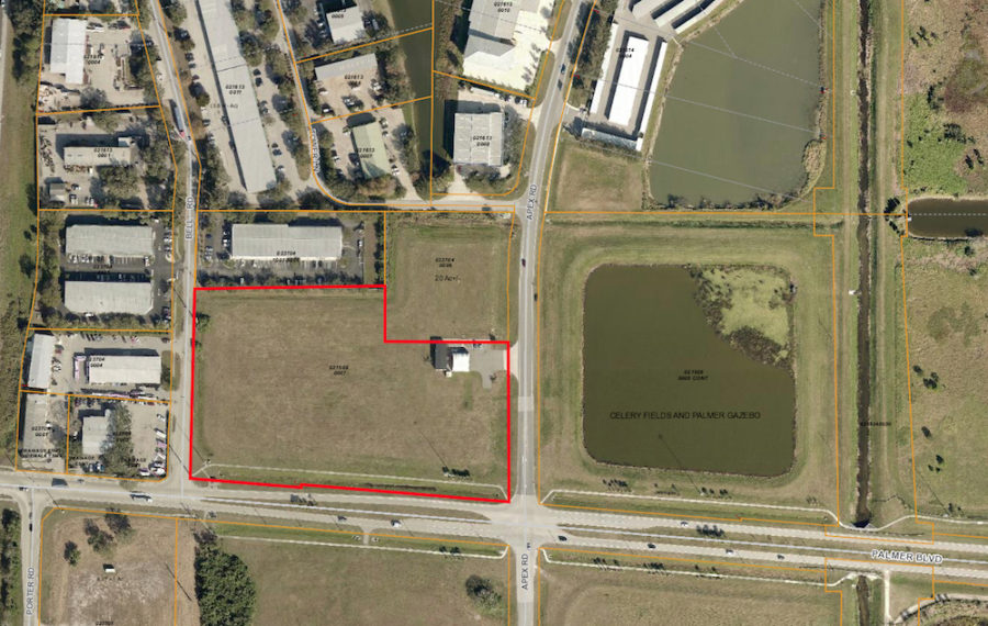
An aerial map shows the Northwest Quad outlined in red. Image courtesy Sarasota County Property Appraiser’s Office
Sarasota County Commissioner Paul Caragiulo won the unanimous support of his fellow board members this week to direct staff to begin analyzing the potential rezoning of a county-owned parcel near the Celery Fields as part of the Fruitville Critical Area Plan (CAP).
The vote followed commissioners’ expressions of conflicting viewpoints on the best use of what is known as the Northwest Quad, one of four parcels remaining from the creation of the Celery Fields stormwater project. A Miami consultant hired by the county to analyze the property said the “highest and best use” — a technical term regarding the greatest financial return to the county — would be as the site of 75,000- to 80,000-square-foot industrial facility. The firm estimated proceeds of $1.3 million to the county in the event the land were rezoned and sold for such a purpose.
However, in response to a question from Caragiulo, Eric Liff, a principal of Lambert Advisory, conceded that the firm did not take into consideration the constraints of the road network in the vicinity of the property.
“Did that come into play at all when you came down to the valuation?” Caragiulo asked.
“We’re assuming that through the development process, there are ways to mitigate [the traffic problems],” Liff replied.
Then Liff told Caragiulo, “That’s not taken into consideration in this analysis.”
Commissioner Paul Caragiulo. File photo
“In this case,” Caraguilo said, referring to the area of Palmer Boulevard and Apex Road, “just about anything [except] a lemonade stand not seating more than five people” will lead to more traffic problems.
“That road can’t be widened,” Commissioner Charles Hines noted of Palmer Boulevard.
Chair Nancy Detert and Hines both talked about the potential of workforce housing on the Northwest Quad, while Commissioner Alan Maio pointed out that leaders of the Economic Development Corp. of Sarasota County have bemoaned the scarcity of property zoned for Industrial, Light & Warehousing (ILW) uses.
“I would not like to see any outdoor facilities that would result in pollution, such as concrete things flying around in the air,” Detert said of the Northwest Quad. “Metal recycling would not be good. … I would really prefer a recreational use, if possible.” However, she added that she would be agreeable to a warehouse with all uses contained inside that structure.
In reference to comments from people who had addressed the board at the beginning of its regular meeting on Oct. 10, Maio stressed, “We’re notgoing to hurt the Celery Fields, and no one here is prepared to do anything that impacts the new use that a stormwater [project] has evolved to.”
As Commissioner Michael Moran pointed out, many years ago, when the county was preparing to undertake the stormwater project that became the internationally renowned bird-watching area called the Celery Fields, the owner of the land insisted the county purchase the four adjacent “Quads” parcels.
Moran noted that the county’s intent always was to sell the Quads.
Before the Kimley-Horn and Associates consulting firm — in which he was a principal owner — created the Celery Fields at the county’s behest, Maio explained, “we had substantial in-structure, in-home intrusions of water during major events.”
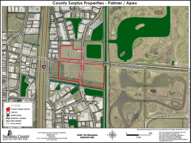
A graphic shows the three ‘Quads’ parcels (outlined in red) originally under consideration for sale as surplus land. The Southeast and Southwest Quads are not on the market, at commission direction. Image courtesy Sarasota County
Later, as Maio also pointed out, the Northeast Quad was devoted to construction of a retention pond that would make the other three parcels open for development without stormwater concerns, thus increasing their value.
“I don’t think there’s a reason to not use [the Northwest Quad] for something,” Maio added.
“Some folks in the public say, ‘Leave ’em all alone,” Hines said. “I disagree with that.”
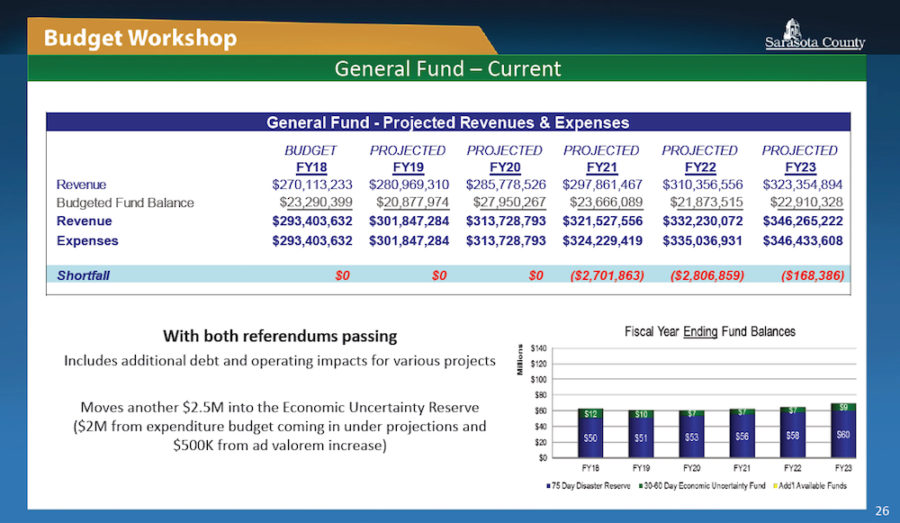
Hines talked of his desire to sell the land because of the need to start building back up the board’s Economic Uncertainty Reserve Fund. Another recession will come, Hines pointed out, and the county is running out of the “rainy day” reserve that previous commissions set aside before the Great Recession.
Maio concurred with the need for the funds the sale of the Northwest Quad would bring. He indicated that comments he has made while campaigning for re-election have been misconstrued. The board approved balanced budgets for the 2018 and 2019 fiscal years, he said, without tax increases. Nonetheless, staff had put hundreds of hours into developing a surplus property list, because the county does need the revenue, he added.
This is the Aug. 22 budget model showing the General Fund projections, factoring in passage of two state homestead exemptions on the Nov. 6 ballot. Image courtesy Sarasota County
“We’ve been very lucky with property value increases [the past few years],” Hines said.
Next steps
After Caragiulo made his motion, Matt Osterhoudt, director of the county’s Planning and Development Services Department, explained that the first step would be for staff to come back to the board with a proposal for the scope of work for inclusion of the property in the Fruitville CAP.
Commissioners emphasized that staff should not feel rushed to accomplish that.
“This isn’t an urgency thing that we need in two weeks,” Hines pointed out, referring to the previous day’s discussion about leasing county land at Nathan Benderson Park to Mote Marine Laboratory for a new aquarium. (See the related story in this issue.)
Maio suggested early January for the staff presentation. “Understood,” Osterhoudt replied.
In response to a Sarasota News Leader question, county Media Relations Officer Brianne Grant wrote in an Oct. 10 email that the work on the Northwest Quad is a two-phase project. The first was the economic and market analysis, which included the Lambert Advisory report. The expense of that phase was $33,695, Grant added.
The second phase will entail the necessary amendment to the Fruitville CAP and the rezoning, she continued, at a cost of $25,345.
Considering the potential uses
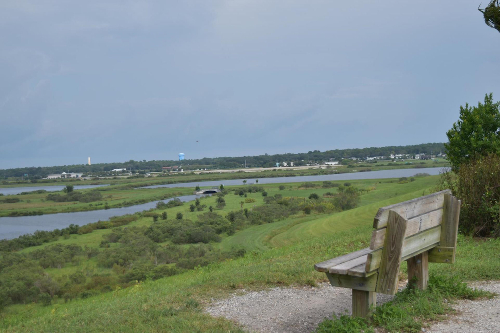
This is one vista of the Celery Fields in eastern Sarasota County. image courtesy Sarasota County
During a Nov. 28, 2017 budget workshop, Commissioner Maio won his colleagues’ support for the hiring of a consultant to consider the highest return on the Northwest Quad that the county could gain through the rezoning of the property. Lambert Advisory won the contract through a county-advertised Request for Proposals process, Maio pointed out on Oct. 10.
The commissioners concurred this week that they want any potential future buyer of the 7 acres available on the Northwest Quad to be certain of the zoning restrictions.
“Though office and residential opportunities comprise higher density development,” the firm’s report said, “their valuations are heavily impacted by the relatively narrow margin between the valuation of operating income and development cost.”
Lambert Advisory put the value of the Northwest Quad at $375,000 if it were to be used for a residential project; for office space, the value would be $150,000.
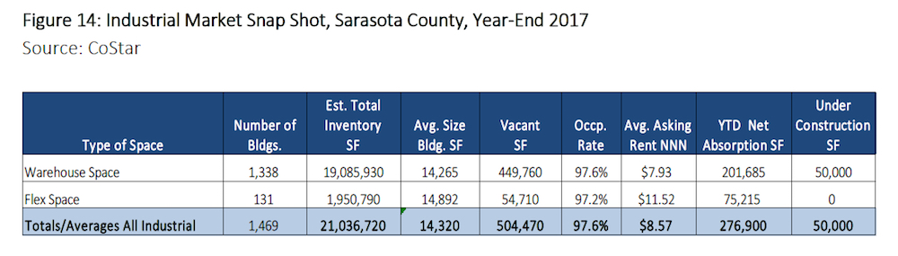
A chart in the Lambert Advisory report provides an industrial market snapshot for Sarasota County. Image courtesy Sarasota County
The report said the Northwest Quad appears to be able to support between 75,000 and 80,000 square feet of industrial development. “At this time, industrial development is the most compatible use relative to surrounding development,” the report adds.
In response to a question from Detert on Oct. 10, Liff explained that the definition of “highest and best use” is “the reasonably probable and legal use of vacant land or an improved property that is physically possible, appropriately supported, financially feasible and results in the highest value.”
Hines first broached the idea of workforce housing on the 7-acre site. (Another 2 acres of the parcel contains a manufactured building housing a fire station; it is scheduled to be replaced with a modern structure for firefighters and EMS crews. The design is underway, County Administrator Jonathan Lewis told the board.)
Hines also told his colleagues he was open to the idea of workforce housing on the Southwest and Southeast Quads.
“There’s a significant amount of jobs in this area,” Hines pointed out. Additionally, “You have a massive park that’s right there,” he continued, referring to the Celery Fields.
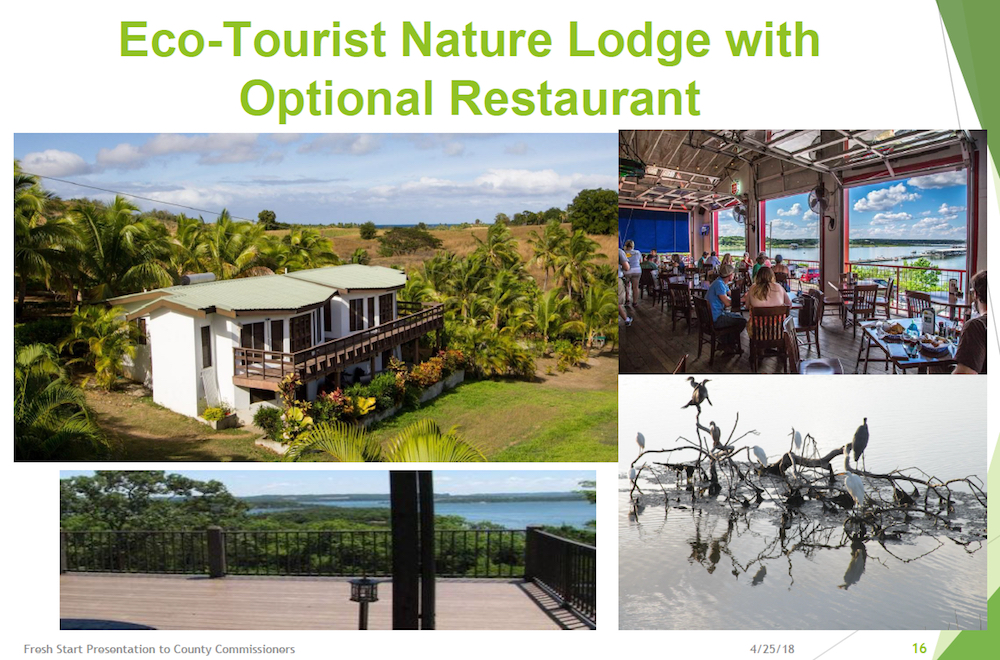
It has proposed recreational uses and perhaps a community center or ecotourism lodge on those other two parcels.
An ecotourism lodge has been one proposal of the Fresh Start Initiative. Image courtesy of the Fresh Start Initiative
Tom Matrullo, one of the Fresh Start leaders, pointed out during public comments on Oct. 10 that the commission already has approved six new housing projects that will entail 3,470 homes “within a short walk or drive from [the Northwest Quad] and the Celery Fields.”
“The Celery Fields is a pretty magnificent place,” Matrullo continued. “Many counties would consider themselves lucky to have it.”
“One thing I liked a lot [in the September Fresh Start presentation],” Hines said, was the potential of creative improvements to the Interstate-75 underpass to provide connectivity to Palmer Boulevard and the Celery Fields. A multi-family development on the Northwest Quad could take advantage of the walking and bicycling options, he added.
“I think that sounds great,” Detert replied.”
Another idea, Detert proposed, would be a combination commercial/residential development with amenities similar to those at Topgolf Tampa. That company’s website touts more than 100 “climate-controlled hitting bays,” a full-service restaurant and bars, private event spaces; a rooftop terrace with a fire pit; and more than 200 high-definition TVs.
“We should actually take advantage of the fact that the Celery Fields are there and continue along that recreational avenue,” she pointed out.
A graphic in the Fresh Start video shown to the board on Sept. 12 makes clear the location of the Quads. Image courtesy Sarasota County
When the commissioners asked about the uses available on the Northwest Quad now, Zoning Administrator Donna Thompson explained that the property is zoned Open Use Rural, which is devoted largely to agricultural uses. Through the special exception approval process, Thompson said, other uses could include a daycare center and a church, for examples.
Michele Norton, manager of the county’s Planning and Zoning Division, explained that any rezoning of the property would necessitate “reopening” the Fruitville CAP.
“I would be fine with having this rezoned to ILW,” Hines said. Multi-family housing and restaurants are among the uses allowed in such districts, he pointed out.
Noting the surrounding businesses, he added, “ILW’s compatible with everything that’s there.”
“I’m just not in any big rush to do anything here,” Commissioner Caragiulo told his colleagues.
Therefore, he continued, he felt an analysis through the CAP process would be appropriate.
The traffic issues have to be addressed, Caragiulo said.
The CAP analysis, Maio replied, “does more flesh out the details of the rezoning … what’s going to be required. “[Potential buyers] gotta know what they’re going to get.”
“I think that actually facilitates a little better community conversation,” Caragiulo said of utilizing the CAP process.
To our Fresh Start HOA's, delegates, advisers and far-flung Celery Fieldsians:
Fresh Start offered a broad view of the context of development and potential in and around the area of the Celery Fields in its Sept. 12th appearance before the Board. We showed visuals of the many thousands of acres of new housing the board has already approved, and asked why elected officials couldn't reserve 30 acres of public land near our birding and recreation area for public uses. (Links to all presentations and correspondence are below).
We've held off on this update to gain a better understanding of two parallel developments, which we'll mention in a minute. But it's important to note that Fresh Start believed our portion of the task was complete when we submitted our update on July 11. We did what we said we'd do: offered community-approved proposals for Quad parcels 1 and 2. Our four specific proposals in April had drawn praise from the Board, but no concrete direction. We were just asked to "refine" them. We surveyed our neighborhoods about sports resources, and the YMCA which did some further market research (which would pertain to all four proposals), and that's what we gave to the Board in July.
We expected a response -- some questions, suggestions, perhaps a directive to county staff to offer an analysis or pursue discussions via the EDC or tourism officials -- but we heard nothing. On August 14, more than a month after our July 11 update, we wrote to Long Range Planner Jane Grogg, our County liaison, asking when or whether such feedback would be forthcoming.
We were simply told to show up on Sept. 12 -- to present. Frankly, we were more than a little baffled. As we had received zero response to our latest update, what exactly were we expected to talk about?
Fresh Start had a choice: We could go and simply stand there, waiting for the Board's thoughts and direction. Instead we chose to offer a broader analysis that would support Board action on one item: Removing the public parcels from the surplus lands list, and working together on future uses:
The Board took no vote. Actually, it didn't discuss the proposed resolution, or any of our community proposals. The only commissioner who addressed practicalities, Paul Caragiulo, said the Board needed to first deal with serious road issues. What we didn't have an opportunity to say is that this was exactly the sort of work the county staff could have been doing all along to help the Board come to a determination. Mr Caragiulo was exactly right, but the County had yet to make a beginning. Commissioners Hines, Moran and Maio said nothing to Fresh Start after our presentation. Commissioner Detert thanked us, characterizing our September report as beautiful yet critical. (Fresh Start believes it's the situation at the Celery Fields that is critical.)
Parallel proposals
Here's where the plot thickens. While Fresh Start was working for nine months -- more than a thousand volunteer hours -- to find, vet, vote, and present our community's ideas, the county had hired a Miami consultant, Lambert Advisory LLC, to assess and rezone Quad parcel #3 for sale, at Commissioner Maio's instigation.
Emails obtained through a public records request show that county staff was working assiduously with Lambert. In August, the firm's assessment was that the county could obtain the highest price for parcel #3 if it rezoned it to industry. The parcel could hold an 80,000 s.f. warehouse or other such industrial operation, Lambert stated.
County staff apparently accepted this assessment and has scheduled the Board to discuss rezoning parcel #3 to Industrial (ILW) on Oct. 10. If the Board wishes, the proposed rezoning will then begin the public process - Neighborhood Workshop, Planning Commission, Public Board Hearing.
Three observations:
1. If the fragile roads need addressing before allowing a simple park on them, as Mr. Caragiulo stated, how is it that staff would approve and forward a rezone certain to generate more large truck traffic?
2. Lambert Advisory's report compared industrial uses with residential, office, and commercial for parcel #3, and states unequivocally that an industrial zoning would bring the highest sale price ("highest and best use" actually means "best price"). Others question this conclusion, however.
One source familiar with the nearby Fruitville Initiative, which has over 200 acres all with the same "MEC" (major employment center) designation as the Quads, says none of the five major Fruitville Initiative landowners is finding interest from industrial developers. Companies seeking to build in that area are proposing a mix of multi-family, condos, homes, offices, and commercial. These parcels are all closer to the highway than parcel #3. If industrial were the best way to realize monetary advantage, why wouldn't someone be rushing to put it there?
3. Fresh Start of course knew that the County had commissioned Lambert's study. We repeatedly asked to speak with Lambert, and were denied by County staff. Which provokes another question: Lambert was tasked with gaining a knowledge of the Community (see scoping document below); how was the mission helped by blocking communication with the community?
More industry
Finally, we must note that James Gabbert has resubmitted his plan to build a waste transfer station on 6 acres he owns that run along Porter Rd. west of parcel #2, with a strip along the southern edge. We only learned about this earlier this week.
No new traffic study will be required for Mr Gabbert's Special Exception, according to County Transportation staff.
To sum up:
While Fresh Start presented, presented, and presented, were we heard? Did any engagement occur? We have yet to hear consideration of what our communities have offered. We are asking when that consideration will take place.
At the same time, an initiative to industrialize parcel#3 is moving ahead, and Mr. Gabbert is moving ahead with plans to put his waste transfer station adjacent to parcel #2, right next to the highway. Will our Communities' concerns, voiced in three presentations, be considered as these industrial efforts go forward? Will parcel #2 go industrial next? And what of parcel #1?
Please stay tuned, and thank you for your ongoing support.
The Fresh Start Executive Council
Glenna Blomquist, Carlos Correa, Tom Matrullo, Gary Walsh